


Maps to download
Download maps of north and south Djurgården, Ulriksdal Palace Park and Fjäderholm Islands.
North and south Djurgården
Download two maps here (north and south Djurgården), printable in A4 format.
The map areas and routes are illustrated with drawings of sights to see and local animal life.
Download the maps. Pdf, 2.3 MB, opens in new window. 2MB PDF document.
Map of horse riding tracks on Djurgården
Djurgården has many kilometres of dedicated horse riding tracks that wind through the landscape. There is now an available map which describes where these horse riding routes go, both on Djurgården and Ladugårdsgärde. Download the map Pdf, 2.2 MB, opens in new window.
Cycling on Djurgården
The Royal National City Park is a historic landscape and an oasis for both relaxation and activity. Cycling is an excellent way to discover the park.
The County Administrative Board has signposted a 36km long cycle path from Ulriksdal to Blockhusudden. The cycle map guides you through "Djurgårdsrundan", "Ulriksdalsrundan" and "Brunnsviksrundan". Download the cycle map Pdf, 4.8 MB, opens in new window.
Maps, Ulriksdal Palace
A map with guided tour of Ulriksdal Palace grounds, an overview map of Ulriksdal and a map of Haga Park.
Walking in Ulriksdals Palace grounds (3,37 MB) Pdf, 291.6 kB.
Map over Ulriksdal (292 Kb) Pdf, 3.3 MB, opens in new window.
Map over Hagaparken (279 Kb) Pdf, 278.2 kB, opens in new window.
"Ulriksdalsrundan" – a historic cycling tour
The Royal National City Park is a historic landscape and an oasis for both relaxation and activity. Cycling is an excellent way to discover the park.
The County Administrative Board has signposted a 36km long cycle path from Ulriksdal to Blockhusudden. The cycle map guides you through "Djurgårdsrundan", "Ulriksdalsrundan" and "Brunnsviksrundan". Download the cycle map Pdf, 4.8 MB, opens in new window.
Map, Fjäderholm Islands
Down load the map of the Fjäderholm Islands, with restaurants, cafés and shops. Note, subject to change.
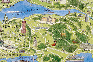
Detailed map of south Djurgården, created by Jan Wahlman and Jonas Adner. Copy: Kungl. Hovstaterna/The Royal Court.
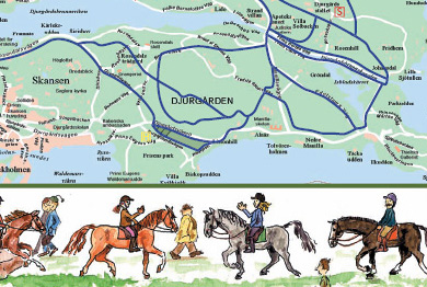
Detailed map of horse riding trails on Djurgården.